purplecat: The family on top of Pen Y Fan (General:Walking)
Because of all the mix-ups with permits and so on, we were offered an additional "free" activity. We picked a trip to the Polccoyo rainbow mountain area. It turned out that there are two rainbow mountains in Peru of which Vinicunca is the more spectacular, touristy, and better known. Different mineral compositions in the soil - particularly copper - cause the geological layers exposed in rainbow mountains to reveal stripes of bright colours. Our guide for the day, Olmer, was obviously from the Polccoyo area and felt very passionately about it. He explained that it was being opened up to tourists in a bid to stave off a proposed investment from a Canadian mining company who wanted to establish a copper mine in the area.

It was beautiful and remote and while there were two or three parties of tourists, it was easy to feel alone in the landscape. B. and I were a bit dubious that it could both retain its character and generate enough income to hold off the allure of mining company big bucks.

Photos )

The road up to Palccoyo went along multiple switch-backs from tarmac to dirt track, and past alfalfa farmers on the lower slopes (the alfalfa feeds the guinea pigs which are a local speciality - if you are interested they taste a bit like duck) to alpaca farmers on the higher slopes (alpaca is genuinely nice meat, quite lamby but more restrained). On the way back down I tried to photograph alpaca from the taxi resulting in a lot of blurry photos of alpaca of which these are the best.

Photos from the taxi )
purplecat: Hand Drawn picture of a Toy Cat (Default)
We had a "free" day in Cusco, but there were some suggestions of activities that our guide could organise for us. Two other people in the group were interested in seeing the Moray Ruins and the Salt Mines of Maras and we were happy to tag along and make the excursion cheaper.

Moray was the first Inca Plant laboratory we encountered. As noted previously, it wasn't quite clear to us why it earned the status of laboratory.

Pictures under the Cut )

The Salt Mines are not actually mines, but a salt extraction plant that predates the arrival of the Spanish and which are still worked today. Mineral rich water from the mountains comes in and fills clay lined pools. The water then evaporates and the salt is collected. They are owned by 300 families and there were people working them - flattening the clay lining - when we visited. I bought salt.

Photos under the Cut )
purplecat: Two dummies wearing Edwardian dresses. (General:History)
Sacsayhuaman is a massive Inca fortress, called the House of the Sun, on a hill top above Cusco. We were taken up their on our first day in Peru, walked around the site and then walked back down into Cusco.

It is quite a thing )
purplecat: Hand Drawn picture of a Toy Cat (Default)
Our Inca Trail holiday actually started with three days spent in and around Cusco, the ancient Inca Capital. Our first day started with a walking tour of Cusco. Because of the various mix-ups with permits, this was with a guide called Arturo who should have been our guide for the whole trip, but wasn't.

Photos under the Cut )
purplecat: The family on top of Pen Y Fan (General:Walking)
Then Wilbert showed us around Machu Picchu.

Photos )

The story of Machu Picchu, as Wilbert told it to us, was that it was under construction as a district capital when the Spanish arrived. Intimating that things were going badly with the Spanish, the Inca moved 700 people and all their gold from their capital of Cusco along the Inca trail to Machu Picchu, destroying the roads behind them with landslides. They remained there for 80 years but were aware that the Spanish, in search of the gold, were getting closer aided by a generation of half-Peruvian, half-Spanish collaborators. After 80 years, therefore, they hid the gold in the surrounding hills and some moved back towards Cusco where they were captured by the Spanish and others moved east into the Amazon where their descendents were briefly encountered by archeologists in the 1970s. The Spanish eventually reached Machu Picchu but found no gold. This story does not appear anywhere else I've looked (but, as noted, information at the level of detail I'm accustomed to for historic sites is much harder to find for Machu Picchu), but it wouldn't surprise me if it isn't the legend as told among the local Andean people.
purplecat: The family on top of Pen Y Fan (General:Walking)
Day 4 started at 3:30am in the morning because we were supposed to meet up with the rest of our party at 11am at Machu Picchu which was about 14km away. Most of the rest of the camp got up and set out around the same time for reasons that were less clear to me - maybe the general plan is to get to Machu Picchu before lunch and then spend the afternoon in the city.

Anyway, this meant the first hour of the walk was in the dark going down steep steps with head torches which, once the novelty had worn off, wasn't much fun. We were, presumably, missing some stunning views.

The first ruin of the day was Intipata. This involved a slight diversion off the Inca road itself. According to Wilbert no one had even known it was there until a forest fire about 25 years ago. It's a bit difficult to convey it in photographs, especially as we don't seem to have managed to take any which have any people in for a sense of scale. It was huge, each individual terrace rising above our heads. As far as one can tell, it was a farm.

Photos under the cut )

We then went to Wiñay Wayna which was very similar except that Wilbert insisted it was a laboratory not a farm. We had previously seen another Inca "Laboratory" at Moray but were somewhat confused by the distinction. Laboratories, we were told, were convex while farms were concave. The convex shape caused microclimates at each terrace and you could see different plants were grown on each terrace so it was obvious that the Inca's were experimenting. B. and I felt a frew crucial steps were missing here for something to be called an experiment, as opposed to growing things where they grow best. I was actually getting rather tired at this point so I just sat down and admired the view at Wiñay Wayna, while B. walked down to look at the buildings disturbing some Llamas who were grazing on the terraces.

More Photos )

Wiñay Wayna was right by a campsite of the same name. It was currently out of use following landslides but was, apparently, where people normally spent the final night on the trail. Having left us to explore Wiñay Wayna, Wilbert sat down and chatted to the various guides and porters working at the camp. When we got back he reported that several other parties had gone past, none going to look at the ruins... which again seemed rather odd. I guess for a lot of poeple the Inca Trail is about the walk and then Machu Picchu and not so much about the less well known ruins along the way.

Once past Wiñay Wayna, we left the controlled part of the Inca Trail. At that point I half expected to start seeing day trippers up from Machu Picchu but we never passed anyone going the other way. Wilbert said this was because day trippers were lazy (Wilbert considered many people lazy, including anyone who spoke Spanish in preference to Quechua) but I would have thought quite a lot of people would like to walk along a bit of an Inca road without necessarily doing so for four days and going over Dead Woman's Pass.

Anyway, we continued for another 5 or so km, mostly on the flat but rising slightly until we came to a set of steps that Wilbert cheerfully informed us were called the "Gringo Killer". He had my measure by now and offered to take my sticks while I clambered up.

Evidence under the Cut )

Then we turned a corner and came out at Inti Punku, the Sun Gate, the ceremonial entrance to Machu Picchu. This is where you get your first glimpse of the city.

Photos )

I'll leave Machu Picchu to another post. We were half an hour "late", but Wilbert had a back-up plan which involved showing us around himself and we bumped into the rest of the party during the tour. I was a little frazzled when we got there - a combination I think of the early start, a fairly long walk and the fact my esim wasn't working so I was out of WhatsApp contact from our other guide and so couldn't coordinate meeting up (I eventually managed to contact him via B's phone). But once I'd sent the WhatsApp message and had something to eat, I cheered up enough to enjoy the city.

I felt even better after a bus ride down to Aguas Calientes and a late lunch.

Evidence of Lunch )
purplecat: The family on top of Pen Y Fan (General:Walking)
Unlike Day 2, which was hard work and not terribly rewarding, we loved Day 3 on the Inca Trail. Once again we set off almost as soon as it was light. Wilbert's plan was again to have all the walking done before lunch, in part because of convenience, but this time he also knew there were a lot of ruins to see and was quite keen to get us to them before everyone else got there. In this he was successful. We generally got to look around ruins on our own, but a big group would arrive just as we were leaving.

The first of these was Runkuraqay which Wilbert described as a fuel station for people, which we interpreted as meaning an Inn.

Runkuraqay Pictures )

We then went up and over a pass, a little lower than Dead Woman's Pass the previous day, and a shorter climb because we'd started higher. Then we came down towards Sayacmarca, a much larger ruin.

Pictures )

Once we left Sayacmarca we continued down to about 3,500m. After that the trail was much more level. Strava shows a steady climb, but I felt much more able to look about me at the scenery rather than paying close attention to where I was putting my feet. As the trail levelled out we got to Qunchamarka, another Inn. It wasn't clear how to access this, but we walked around the outside. I think at this point we were up in a Cloud Forest - though I'm hazy on the difference between Cloud Forest, Rainforest and regular forest, all of which I think we walked through at various points.

Pictures )

Wilbert spent some time telling us about the Inca Tunnel we would meet. B was pretty sure this was just a large fallen rock which the Inca's had run the path under. Wilbert got distracted at this point since he found a dog in the brush above the tunnel. After some encouragement he got it to climb down and it ran off down the path ahead of us. We met it again at the next campsite where, presumably, it belonged. I'm afraid we failed to photograph the dog, so you'll just have to imagine it.

B did photograph the tunnel, however )

We arrived at our campsite in good time for lunch. The camp was above another Inca ruin, Phuyupatamaca, and after lunch Wilbert packed us off to take a look at it on our own. This involved going down some steep steps and it seemed like the water source for the camp was at the bottom, because we were passed by a lot of porters carrying water back up them. At the time we assumed he sent us to look at it then, rather than the next day, because the plan was to leave before light so that we would get to Machu Picchu in time to meet up with the rest of our group. However it transpired that pretty much everyone was leaving before light and we seemed to be the only party who's guide thought to encourage us to check out the ruins we would miss in the dark.

Pictures of Phuyupatamarca )

We had an excellent position in the camp right next to a large rock that overlooked the view. We were next to the camp of a group of three people who were on the "Luxury" tour. Wilbert was very contemptuous - they had three guides and a masseuse. They were also served cocktails in glasses made of glass when they reached camp. The most disconcerting thing was that they were played into camp by Andean pipes. B felt he would have been quite happy with the cocktails and the larger tents (including a shower tent!) and so on, but felt he wouldn't have coped with the pipes.

Pictures in the Camp )
purplecat: The family on top of Pen Y Fan (General:Walking)
Day 2 on the Inca Trail was the least fun of the trip. We had to climb 1,200m to get up and over "Dead Woman's Pass". Wilbert, our guide's plan was to get going as soon as it was light (around 5:30am) and aim to reach our campsite at lunch time. His reasoning was to get most of the actual climbing done while we were in the shadow of the tall mountains around us. It also made life simpler for the support team who wouldn't have to pick somewhere en route, unpack to make lunch, and then pack up again to get to the campsite. He also, I think, quite liked the idea of catching up with the group that were ahead of us who were starting around 700m up the climb and who would be having lunch at our evening campsite. In the event we arrived at our campsite about 2 hours after they had left, having another pass to go over before they got to their campsite for the night.

We were on modern trails, according to Wilbert, and although I think we passed some Inca ruins at a campsite en route, we didn't look at them. Wilbert's explanation for the route wasn't entirely clear. As I understood it the original Inca road went over a different pass, though I never figured out if it was higher or lower. I got the impression a large section of the road from Cusco to Machu Picchu was destroyed by the Inca themselves, triggering landslides, in order to prevent the Spanish finding their way along it, so maybe that explains why we were following a modern alternative.

We started at about 3000m. At around 3,700m I began to feel quite tired and a little concerned about the 500m still go. At 3,900m as we came out of the shade and into the sun, my legs felt like lead and I made it up to the pass only by doggedly walking 300 steps and then stopping (300 steps, if you are interested, gets you up about 50m). At the time we put this down to the fact Manchester is super-flat and so our uphill muscles don't get a lot of exercise. However, I wasn't remotely stiff the next day, at which point it occured to us to measure my blood oxygen using my watch. It was down at 81%, rising to 88% if I took several deep breaths (B., in contrast was generally in the high 80s/low 90s). So it's possible the issue was lack of blood oxygen - even though I wasn't showing any other symptoms of altitude sickness.

Once over the pass we descended around 600m to our campsite. I badly wanted to go to sleep, but B. and Wilbert forced me to have some lunch first. Then I slept for an hour, after which I felt much more like myself.

We walked a total distance of just under 12km.

Pictures under the Cut )
purplecat: The family on top of Pen Y Fan (General:Walking)
We did our Inca Trail holiday with Explore! who (out of necessity as I understand it) subcontracted to a local tour company. At some point something went wrong with getting permits for the trail. The story we were told was that the local agent forgot to apply for our permits, but several other people in the group had had permits delayed, so we concluded that there had been a more general permit mix-up which was simplified for our consumption as "forgot to apply for your permits". The up-shot of all this was that instead of travelling as part of a group of ten walkers with a guide, cook and porters it was just the two of us with a guide, cook and porters, setting out a day after everyone else with the aim of catching up with them at Machu Picchu. This was a mixed blessing, we got a lot more time with our guide and didn't have to worry that we were slowing anyone down, on the other hand it felt like an awful lot of staff for just us and even though our guide as very good at leaving us alone for various stretches, or sending us off on our own to explore things, it was quite intense.

Photos and more under the cut! )
purplecat: Scene from The Prisoner.  Everyone in multi-coloured capes. (The Prisoner)
I never posted the photos I took when we were in Portmeirion for Christmas.

So please find them below the cut. )
purplecat: The family on top of Pen Y Fan (General:Walking)
While B. and I are not habitual Scottish mountain climbers, we have both climbed a fair few in our time. In fact I had climbed Ben Nevis as a teenager with my father. So we, broadly speaking, feel we know what we are doing when it comes to mountains. The various guide books and websites warned of unexpectedly bad weather at the summit, and the possibility of falling off a cliff to your death in the mist, and advised taking survival gear, first aid kits, spare clothing and numerous other items up the mountain.

It was a Saturday in August, the world and his wife would be climbing the mountain, and the weather forecast said it would be cloudy but dry. We were pretty sure we knew what we were doing and set out with the walking gear we had taken with us all trip. We were walking up what used to be called the "The Tourist Track" but has been rebranded the Mountain Track. How hard could it be?

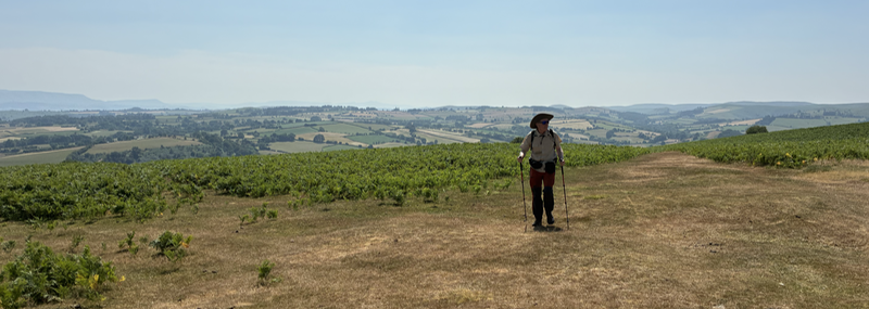
The World and his Wife were, indeed, climbing the mountain. Our excellent taxi driver advised starting (and ending) at the Ben Nevis Inn which made the route a little longer than starting at the Youth Hostel but with a smidgen less up. We found ourselves more or less in a queue of people going up the mountain. Occasionally energetic looking souls ran past us in the opposite direction (more of this anon). The going was steep but steady and, indeed, the Strava profile shows a steady gradient all the way up. The path alternated between gravel, paved steps, and the odd rocky patch that needed to be scrambled over. We set off just before 9am. Around 11:30 we crossed a stream below a waterfall which seemed to be giving people pause - I say "seemed" because this manifested as largish crowds either side of the stream eating sandwiches. The path then started zig-zagging up the mountain. By this time the crowd had thinned a bit, and it no longer felt like walking in a queue.

It was when we walked into the cloud covering the top of the mountain that things began to get a bit trying. The wind picked up and the non-existent rain started out as "Scottish Mist", upgraded to drizzle and then began to rain in earnest. The visibility slowly got worse until we couldn't even see the next cairn from the current one, and I could barely see at all because of the rain on my glasses. We passed someone lying on the path in an orange survival bag, surrounded by anxious friends. Around this point, it occurred to me that I didn't have a survival bag and should I slip and twist an ankle, I'd be stuck two thirds of the way up Britain's highest mountain, in a rain storm in only the clothes I was wearing until such time as Mountain Rescue arrived.

It got colder. The wind picked up.

We reached the top at midday. B. suggested I have lunch. "I don't want lunch, I just want to leave!" I said. The rain was cold and I was losing feeling in my hands, because I'd foolishly come without gloves (though B. said his gloves, once wet, didn't help much).

I did take a photo )

We headed back down as the weather got dramatically worse. The wind became a gale. The rain almost, but not quite, became hail. I lost all feeling in my fingers which were gripped around my walking sticks. I could barely see. As B. noted, it was a good job the World and his Wife were climbing the mountain since even if we couldn't walk from cairn to cairn, we could walk to the next person.

I don't think I've ever been on the summit of Ben Nevis when one could actually see what the terrain was like but some googling tells me that it looks like this.

Ben Nevis Summit )

Anyway, we didn't fall off and the weather slowly improved as we descended. The person in the orange survival bag was gone. The details were a bit unclear but it sounded, from the gossip around us, that they had been stretchered off the mountain - possibly to be collected by the helicopter that we heard for a long time before we could see it, hovering above the path.

Mountain Rescue Helicopter )

Once out of the clouds it honestly wasn't that bad. It wasn't raining. It got gradually warmer. Feeling returned to my hands. We were both very tired once we got back to the Ben Nevis Inn which served an excellent bitter and where I, finally, ate my lunch.

As we left the inn in another taxi, Mountain Rescue were once again unloading stretchers to head back up the mountain. The taxi driver told us that there is a race up the mountain a the start of September and Mountain Rescue are always particularly busy that day. It took us around 7.5 hours to get up and down the thing, the running record is just over an hour and twenty minutes.

I hope, on any other mountain, we'd have given up about half an hour into the mist and rain. The only thing that made this remotely safe was the sheer number of people on the mountain. If I had needed a survival bag, them someone nearby would have had one, and a walkie talkie. Even so, it was a salutary lesson in not taking Scottish mountains for granted.

On the plus side, adding in Ben Nevis (just over 5 miles up and 5 miles down), meant we topped 100 miles walked for the trip and B, who had never been up Ben Nevis before, got to tick it off his bucket list.
purplecat: The family on top of Pen Y Fan (General:Walking)
We left Kinlochleven up a steep path which the guide book described as being almost as high as the Devil's Staircase but a less good path. It was honestly OK and we got nice views of Kinlochleven as we left.

More included photos under the cut )
purplecat: The family on top of Pen Y Fan (General:Walking)
This was the shortest leg of the trip and the weather forecast had been consistently unpromising. However by Wednesday night, it was beginning to look like the worst of the rain would be done by midday and since we didn't have to checkout until 11am we opted to remain in our infeasibly large room (admittedly without much of the luggage) until 11am.

It was raining pretty steadily as we left. The first hour was spent walking more or less alongside the A82 through Glencoe. Then, just as the rain began to ease off, we swung right and began to climb out of the glen up the Devil's staircase (which even the guide book admitted was not as bad as it sounded).

More and photos under the cut )
purplecat: The family on top of Pen Y Fan (General:Walking)
Knowing we were about to embark on the longest section of the way, we left Tyndrum early. We'd hoped to be gone by 8am, but in the event it was closer to 8:30am. Fortunately the whole leg was on good paths - often wide enough for a Land Rover or similar. The weather promised to be clear, which was a relief, and indeed we had almost perfect walking weather - not too hot with blue skies - for what promised to be the most spectacular part of the walk.

More, including photos, under the cut )
purplecat: The family on top of Pen Y Fan (General:Walking)
The American group we had been playing leapfrog with on day 2 reached the Ardlui hotel an hour after we did - in fact we saw them coming down the hill as the ferry left. They walk faster than us, but take longer breaks. We went back to the east side of the lake with them the following morning though the ferry was delayed because "Jerry" wasn't ready. We sat in the boat, in the rain, while people tried texting and phoning Jerry to tell him to get a shift on or they would leave without him. We didn't see a lot of them after that, except for a brief glimpse around lunchtime when two of them were waiting for a third who had been delayed on the path. Just as we were wondering if something had gone wrong, she turned up, annoyed that they hadn't continued without her since she had sent a text.

Anyway, it rained all day - not so many photos since extracting the phone from waterproof locations was a pain.

The first couple of miles (which were part of the previous leg) took us away from Loch Lomond over a rise and then down the other side to Inverarnan. From there we followed the River Falloch up past many waterfalls, on a path that varied from one person wide, to something that was clearly an access route to a hydro station.

Photos of waterfalls )

A "sheep squeeze" - not as low and narrow as the guide book led us to believe - took us under a railway. We then went under the road that goes from Loch Lomond to Crianlarich and, from there, into the Highlands. I am familiar with this road from many holidays on the Ardnamurchan Peninsula as a teenager. We then climbed into a large plantation of trees that took us up and down a fair bit as we skirted Crianlarich. Then back down again, across the road once more and through some farmland where I saw my first (and so far only) Highland Cow.

Photos under the cut )

It was, by this point, about 3pm and the rain was finally easing off. The way ambled over and along the river, back alongside the village of Tyndrum, back across the road, back over the river and across the road once more to the Green Welly Stop (which is, honestly, a glorified service station but one which I had fond teenage memories of). Next to the Green Welly Stop was the Tyndrum Inn, a basic hotel very much geared to walkers, where we stayed the night.

It wasn't, to be honest, as hard a day as the walk around Loch Lomond, but it had been long with over 600m of ascent, mostly in the rain and were pretty tired. Finding that some websites mysteriously didn't work on our computers (though they did on our phones) didn't help - we've since worked out that the hotel must have been maintaining a white list, but that this was circumvented by the university VPN running on our phones.

Medical TMI about feet )
purplecat: The family on top of Pen Y Fan (General:Walking)
We were woken in the night to the sound of thunder and torrential rain. It had eased off a little by the time we set off just before 9am, but the weather forecast predicted rain until midday.

At this point the West Highland Way offered the choice between the traditional low path and a high path, put in place at some point when the low path "became dangerous". The guide book was full of statements like "This final section up Loch Lomond has a somewhat fearsome reputation" and suggested the high path was easier. Given our issues with age-related decrepitude the day before, we opted for the high path. This was a wide gentle upward slope following the path of the old military road which carried the red coats into the Highlands to suppress the Scots. A bonus advantage was that this meant we could carry umbrellas instead of sticks. Occasionally we got glimpses across Loch Lomond when the mist rose above sea level.

More including photos under the cut )
purplecat: The family on top of Pen Y Fan (General:Walking)
The day began with the first big ascent of the walk up Conic Hill (1,107 feet, 310m). This was mostly through wooded plantation but eventually this opened out onto traditional Scottish wide open hill country with views of Loch Lomond.

More, including pictures, under the cut )
purplecat: The family on top of Pen Y Fan (General:Walking)
A good walking day. Mostly clear, but cool with only a few spots of rain. We walked the 12 miles from Milngavie (pronounced Mull-guy) to Drymen (pronounced Drimmen) in a little over 5 hours, which necessitated then spending an hour and a half in a pub waiting for the B&B to open. The walking was pretty gentle, on good paths, though the final section was along a road which was quite dull.
photos under the cut )
purplecat: The family on top of Pen Y Fan (General:Walking)
We are in Glasgow. But not at Worldcon.

Tomorrow we head north on foot.

TBH, if I'd been paying more attention when B. decided he didn't want a family holiday in Japan I could probably have combined the walk with Worldcon, but I wasn't, so here we are.
purplecat: Scene from The Prisoner.  Everyone in multi-coloured capes. (The Prisoner)
On Thursday we awoke to bright blue skies and snow on the mountains. There had been some discussion on Wednesday about whether we should, perhaps, leave the village at least once during our stay. B. was initially keen on the idea of a steam train but then cooled when it occurred to him that this would mostly be spending three hours on a train. However, by this point Marmalade Sparrow had been told about the possibility of a steam train and was strongly in favour of it and against the alternative option of a castle. After a bit of negotiation we decided to ride from Porthmadog (near the village) up to Blaenau-Festiniog (the place has one F but the railway has two. I got the impression that the railway's additional F was some kind of publicity move to emphasise its welshness). Anyway we enjoyed the journey, though there is not, frankly, a great deal to do or see in Blaenau - but it got us up to the snow line so B. could touch actual snow. The views from the train were lovely but we would probably have been just as happy though if it had taken an hour less time!

Pictures under the cut )

Profile

purplecat: Hand Drawn picture of a Toy Cat (Default)
purplecat

January 2026

S M T W T F S
    12 3
45 678910
11121314151617
18192021222324
25262728293031

Syndicate

RSS Atom

Tags

Style Credit

Expand Cut Tags

No cut tags